Prevailing winds are the direction that the wind blows most often in a location. Prevailing winds can change by location and by season making it tricky to determine reliable wind patterns in your area. A person might be interested in knowing about their local wind patterns for planning windbreaks, directing air flow, avoiding unwanted odor or air pollution plumes, designing an airport, or many other reasons. Here, we will review wind patterns, their causes, and ways to identify the direction of your prevailing winds.
|
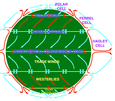
| Diagram of global wind patterns provided by PBS.org |
On a Global scale, wind moves in patterns based on latitudes because of the earth’s spin and differences in sun exposure. In the tropical or lower latitudes winds move east to west and are called the Easterlies. In the mid-latitudes of North America, Europe and Asia, winds move west to east, naming them the Westerlies. Here, in the United States, it is common for weather patterns to follow winds in a west to east movement.
Although the prevailing winds typically follow this general pattern, seasonal changes in wind direction can also occur. Changing wind patterns based on season are called Monsoons. Monsoons are typically associated with India and Southeastern Asia, but we also experience a monsoon season in late summer to early fall in North America. This monsoon occurs as moist air over the Pacific Ocean and Gulf of Mexico travels north and west to the dry areas of the Western United States, bringing the rain to the deserts and causing a change in the persistent winds for a time.
The larger wind and weather patterns may be predictable, however local landscape features may affect the direction of prevailing winds in your location. Things nearby that may influence your wind patterns are mountains, oceans and other large bodies of water, forest boundaries, urban areas and other variations in elevation, moisture or temperature. The best way to determine the direction of prevailing winds at your home or business is to document the wind direction each day for a period of time. You can do this by setting up a weather vane or simply going outside and stand facing into the wind. Paying attention to wind is the best way to learn the patterns in your area.
You can also start noting the weather report for your area, although this may not be as accurate since they are reported from another location. Some weather stations provide easily accessible long-term data where prevailing wind directions may be found by month or year. Sometimes wind data is displayed as a wind rose plot. A wind rose plot indicates the frequency of wind blowing from each direction. The longest ray points in the direction the wind has been recorded most often over a period of time. Here is a link provided by the United States Natural Resource Conservation Service (http://www.wcc.nrcs.usda.gov/ftpref/downloads/climate/windrose/) with prevailing winds by location and month. Start by choosing your state, and then nearest city to view a wind rose (NOTE: open the .gif file). See how winds can change in a location from month to month, or more commonly, season to season.
Here is a comparison of a wind rose depicting weather patterns in Athens, GA for the month of January and August
(Credit: USDA Natural Resource Conservation Service)
The strength and direction of prevailing winds are helpful to understand and plan for when deciding tree species and planting locations. Properly chosen tree species will withstand any prevailing wind issues in your location. Well placed trees will reduce the impact of any cooling winter winds. They may also reduce the amount of cooling summer winds too however. Care should be taken to speak with a professional arborist or urban forester about options available to you in your given location.